The Evolution of the Armenian Alphabet - 2007

The Evolution of the Armenian Alphabet

http://www.tacentral.com/manuscripts_miniatures/images/bigmap.jpg

The Art of Writing

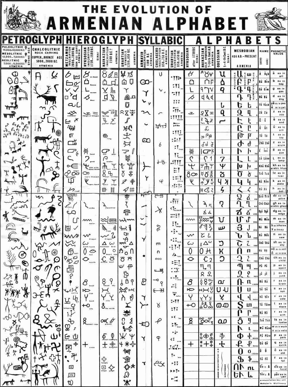
Strange markings on a hillside curiously match the eloquent letters on parchment. The graceful arch of vowels and consonants devised in the 4th century CE are echoed in carvings showing the sun, moon, and the exact locations of constellations from the zodiac. Our guide smiles, and astonishingly covers 20,000 years of writing in a single sentence, "From stone to paper, you can find the curve of our people in a single path. Most people think the Armenian letters began with Mashtots in 406 CE.

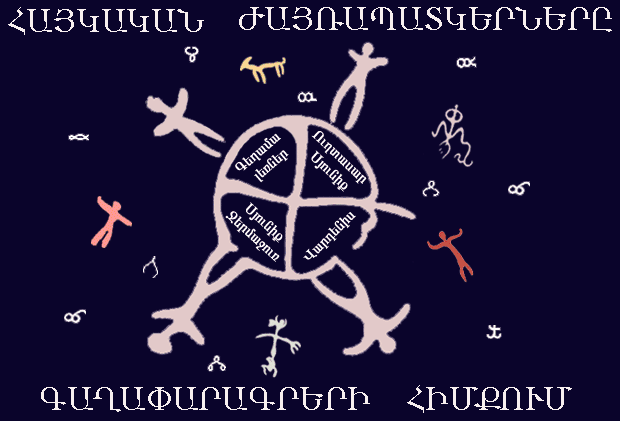
But look here, and you will find a divine inspiration 19,000 years before then." Beginning from astral symbols found on the Geghama Lehr (Mountain Range) between Sevan and the Ararat Plain, including the signs of the Zodiac and star positions at Karahundj and Metsamor; to Vishaps, obelisks covered with cuneiform and pictograms, the Armenian language has its roots. From the heart of Noah to the furthest stretches of Mesopotamia, India and Europe, it spread to encompass most of the Old World. The guide points to controversy and historical fact, to scientific research and popular myth as he gathers energy with his argument. "The glories of manuscript art have their ancestors, just as we do and if you want to believe that the center of language and culture came from this part of the world, then you can’t also believe the Armenian’s were illiterate at the same time. There is a source, and it came before the Mashtots Script."

Beyond stone carvings (called "pictograms", since they represented ideas through pictures, as opposed to an alphabet, which captures sounds and is used to create words and sentences to express ideas), there is very little to suggest what a native language was like in Armenia between the Paleolithic and Urartian periods. Detailed maps showing ancient fortified towns and roads that exist to this day are scrawled on the sides of stone foundations, as are complex trigonometry and geometric formulas pointing to astral, solar and lunar phases. The inscriptions even include one of the first calendars and compasses ever created. The Metsamorians and their ancestors were the earliest known civilization to forge copper, bronze and iron, they created a pantheon of gods that foreshadow the Greek pantheon. Having one of the greatest cultures of the Bronze Age (the "Metsamor Kingdom"), Ancestral Armenians curiously left no written words behind.


Emma Khanzatian, director of excavations at Metsamor, and the Grande Dame of archeology in Armenia, does not find a missing language all that curious.

"It is impossible to have a culture this advanced with no written language," Ms. Khanzatian says. "Just impossible. They were among the leaders in the known world at that time in science, industry and trade. Metsamor era artifacts are found in Egypt, Syria, Persia, India and Central Asia. Their distinct black and geometric pottery made its way to Mycenae, they may even have created the wheel. They knew trigonometry, astronomy and geomtetry--you can have none of these sciences without notation, the forms of writing. How could they leave nothing in writing behind?"

Part of how is shown by several strata of excavations at Metsamor and other ancient cities. Black, charred earth, pottery and skeletons lie in heaps in several layers from the middle Bronze and early Iron Age. Sieges and burnt earth policy began far before recent memory. If anything like parchment was created along with spectacular bronze and gold objects uncovered at Metsamor, AdaBlur, Jerahovit and MokhraBlur, it was surely burned along with the population. More recent layers of excavation show continued sieges and burning in the common era, including a 4th century layer that was a result of struggle between Pagan and Christian armies. It is not until the Urartian period (ca. 1300-550 BC) that a written language has been found and that was borrowed from Sumerians and Assyrians. Stone was the preferred medium of expression, though there is some proof that wood and leather parchment were used along with clay tablets in Mesopotamia and Egypt. But other than signs of zodiac, maps and geometric equations, no signs of writing from the Metsamor period have been uncovered.

Khanzatian smiles and nods her head towards a central mound at Metsamor. "We haven’t begun to uncover what lies beneath this ground. And just think what must be under a city as old as Jerahovit or Aigeshat. Just because we haven’t found it doesn’t mean it isn’t there." A wizened face carved from years of excavating the windswept earth on the Ararat plain laughs and points to the central mound. "And somewhere under the main citadel lies a treasure as important as any gold artifact the archive."

Source: http://www.tacentral.com/manuscripts_minia...s/writing1.html


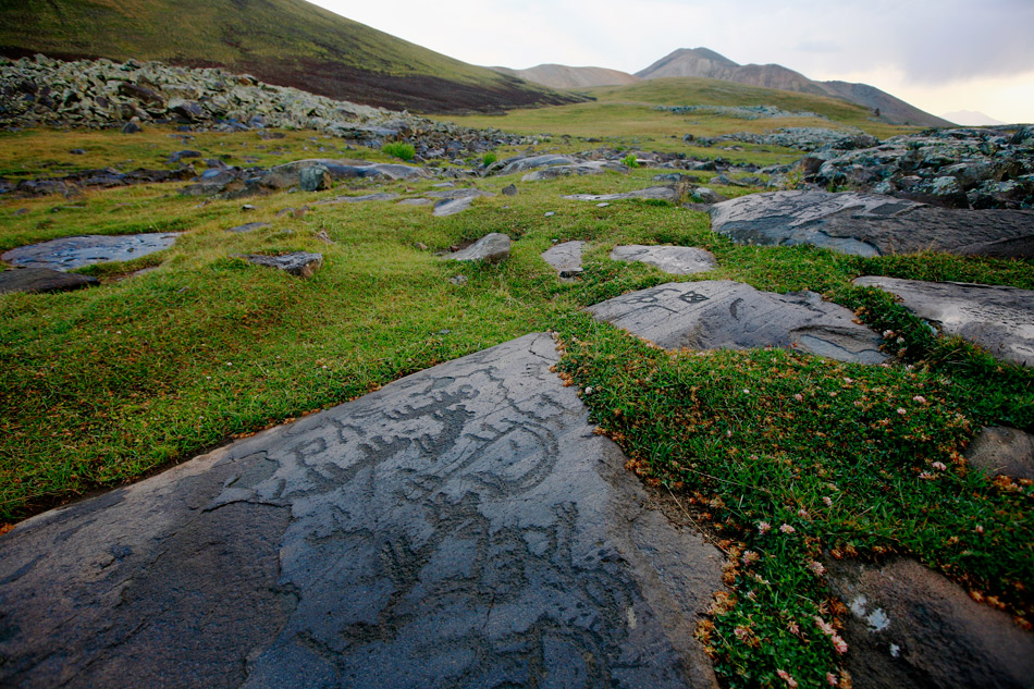
Petroglyphs From Armenia, 9000-3000 BCE

http://peopleofar.files.wordpress.com/2013/12/neolithic-petroglyphs-in-ukhtasar-mountains-armenia.jpg

Before hieroglyphic writing was developed, between 9000 and 7000 BCE, people of the Armenian region expressed themselves by carving and painting designs on rocks. These three pictographs (see source link) were executed between the 8th and 4th millenia BCE, (9000 to 3000 BCE). According to archaelogists, the drawings are associated with Neolithic cultures, especially in the higher mountain regions (Aragats and Aghmaghan and the basin of Lake Sevan). Around 3000 B.C.E., the Proto-Indo-European family of languages was probably closely unified, but by 2000 B.C.E., Greek and two extinct languages, Hittite and Sanskrit, were distinct languages. Though changes in grammar and meaning have taken place, analysis of vocabulary indicates that the people of the ancient Indo-European culture were metal-using farmers tending domestic animals. Recent discoveries suggest links to the Kurgan people, who lived on the steppes west of the Ural Mountains. In the Kingdom of Van, 810 BCE, inscriptions of economic and sacrificial nature were written in hieroglyphics. Specimens of Armenian hieroglyphics are also evident in Urartean excavations at Karmir-Blur, where pottery, bronze cups and cylinder seals were found. This type of writing was used by peoples living on the Ararat Plain, even before the penetration of the Urartian tribes, according to excavations at Cholagerd.

Source: http://images.google.com/imgres?imgurl=htt...6lr%3D%26sa%3DN

Armenian Petroglyphs - 2007

Armenian Petroglyphs

http://www.iatp.am/ara/sites/gaghap/pics/ind1.gif

The Rock Arts of the Armenian Elevation are the Primary Source of the Armenian, Egyptian, Indian and Hettitian Ideograms (Hieroglyphs)

It is known, that with the appearance and the development of language the man is becoming a unique “symbolic animal”, passing a way from a biological being to a thinking one. But the reason is that the language, as an informatics object is a developing, open, huge library of interactive symbols, elements. Each of the elements is modeling, projecting and means one appearance of the world, out of the edges of the human race particularly and entirely. Taking in set that symbols and elements are summarized in one image of the space, environment, where live and create the users of that language. As the natural conditions, in which our forefathers lived, and the situation, which is expressed by the representatives of that culture, in many cases are changed from one ethnos to another, in the result we observe differences in the languages of various ethnic groups, and, in some cases, the differences are not essential in one ethnic group.

As the authors think, these differences obviously appeared in the stages of the development of rock art, rock images and pictures. Sometimes the graphical languages (executive manners, typical forms, etc.) of various ethnic groups are non-similar. It is supposed, that the complexes of the rock images, which were discovered on the historical territory of Armenia, are differed from each other in a measure of mental characteristics and dialect differences of the representatives of Armenian people from various parts and regions of Armenia. The graphical language, symbols and signs are available. They are invariant and never depend on time, geographical and natural coordinates. Many nations had successfully learned and developed this language. Language symbols are general and understandable basically in the limits of one ethnic group, in determined geographical space and time. The authors think that just the moment of the investigation of the graphical archetypes is supposed to be the start of the civilization. The graphical image, picture, symbol or sign, which is fixed on the stone, exists singly, never depends on its creator - «is alienated from him». All this systems possess by the feature of autonomy and independence. Linguist V.V. Martinov call the language – “Actuality – 2'', in diversity of “Actuality – 1”, which is the world environment.

The graphical language, the language of petrography and rock pictures allowed a floating, harmonic and efficient (less actions) passing from ''Actuality – 1'' to ''Actuality – 2''. The construction of ''Actuality – 2'' relative to the objective, real or imaginable process, weighing of negative and positive features, hesitation in sincerity of thoughts, projection and development of the structure of logical constructions, choice of more acceptable decisions and their spreading – for all mentioned the man and the human language are obliged to the features of graphical language, as well as to simultaneity, invariance, reflectiveness, regularity, totality, etc. The hieroglyphs or the symbols (the word “ideogram” comes from the Greek words “idea” and “I’m writing”) have a significant place in the history of letter writing. Hieroglyphs usually considered to be the first step in the development of letter writing and were on the lowest development degree, as if they do not express sounds or syllables. They express whole words or parts of them and, naturally, do not submit any grammatical rule and cause serious difficulties in reading. Egyptians, Shummers and Chinese implemented this kind of letter writing. The ancient nations, such as Armenian, also had hieroglyphs in their letter writing...

Source: http://www.iatp.am/ara/sites/gaghap/index.htm
Olive tree was brought into Palestine from Armenia 4000 BC

http://www.importpeace.org/images/black_olives.jpg

Zaitounah Museum new addition to Tunisian heritage

The Zaitounah (olive) Museum which was opened recently in the eastern city of Sousse is considered a new addition to the Tunisian cultural heritage due to the pivotal role the olive tree plays in the lives of Tunisians and the population of the Medieterranean region. [...] Gadira said that it also aims at preserving the heritage of this "blessed" tree for future generations, noting that this tree remained steadfast before the various civilizations which ruled Tunisia over some 3000 years like the Berbers, Phoenicians, Byzantines, Arabs, Spaniards and Turks. He said that the most ancient documented sources available report that the olive tree was brought into Palestine from Armenia 4000 BC and then taken by the Phoenicians to Greece and later to North Africa, particularly Tunisia. Since the ancient times, olive oil was the choice of the elite and notables in Tunisia and other countries of the region. It was used in religious rituals, as a massage oil, producing perfumes and for other medical purposes. According to the latest figures, there are an estimated 55 million olive trees stretching from the country's north to south and covering an area of nearly 1.6 million hectares or 30 percent of Tunisia's farmlands. Tunisia is the world's second largest producer and exporter of olive oil after EU states, mainly Italy and Spain. Article originally published by Kuwait News Agency (KUNA) 12-Jul-04

Source: http://www.kuna.net.kw/English/Story.asp?DSNO=648372

Pantheon of Armenian Gods And Godessess - 2007

Pantheon of Armenian Gods And Godessess

http://www.armenian-history.com/images/pictures_photos/Tir_Apollo_Armenian_god.jpg

The first god in Armenia was one of the language’s first sounds, ‘AR’, which means sun or light. As the source of life, the sun became equated with power and the supreme god. Ararat is mentioned as early as ca. 6000 BC in the Sumerian epoch poem Gilgamesh, as the land of the mountains where the gods live. The word Ararat can be divided into three words: AR-AR-AT. AR-AR being a plural form or all encompassing god; ‘AT’ being an archaic version of the Armenian word ‘hat’, which means ‘a piece of’. Thus Ararat meant ‘a piece of gods, or a piece of creation. Early symbols for gods are closely connected with astral symbols. The first use of the sacred swastika and cross are found in ca. 20,000-15,000 BC inscriptions in the Geghama Mountain Range. Carvings dating back to ca. 8500 BCE show symbols associated with astronomy, giving them a god like prominence: the sun, moon, and constellations were thought to be deities in themselves, and astral occurrences such as an eclipse or a comet were considered communication from the gods. By the 5th millennium BC, Ancestral Armenians combined sun worship with sophisticated astronomy. They are now credited with assigning the constellations of the zodiac their design and names, and creating one of the first solar calendars based on 365 days in the year. Also around the 5th millennium BC a series of Vishaps (Dragon Stones) began to be erected on mountainsides throughout Armenia, near water sources. At first resembling fish (dragons in Armenian were thought to be huge fishlike creatures, something like a cross between a whale and a gigantic squid), the monolithic stones were later carved with snakes, the heads of beasts, swastikas and crosses. Around 3000 BC, Ancestral Armenians had created a specific iconography and pantheon of the gods. The Armenian gods were still centered on the worship of the sun, but by the Urartian period, they resembled Mesopotamian and Egyptian deities based on animal-human combinations.

Human deities emerged during the Armenian Hellenistic period. Though bearing remarkable likeness to Greek gods and goddesses, which first gave speculation as to their Greek origins, it is now thought that many of the Greek gods are actually inherited from Ancestral Armenian sources, with some coming from as far away as India. The heroic legends of Hercules, for example, were first attributed to the legend of the Armenian king-god Haik in the 3rd millennium BC.

Pantheon of Armenian gods: the Armenian god or goddess is listed with the Greek equivalent deity in parenthesis.

Aramazd (Zeus) - The father of all gods and goddesses, the creator of heaven and earth. The first two letters in his name, "AR" is the Indo-European root for sun, light, and life. Aramazd was the source of earth’s fertility, making it fruitful and bountiful. The celebration in his honor was called Am'nor, or New Year, which was celebrated on March 21 in the old Armenian calendar (also the Spring equinox).

Anahit (Artemis) - The goddess of fertility and birth, in early period she was the goddess of war. By the 1st c. BCE she was the main deity in Armenia.

Nuneh (Athena) - The goddess of wisdom, common sense, motherhood and protector of the home, keeper of the family.

Vahagan (Hephaestus) - The god of thunder, clouds and fire. Comes from "Vah" -god, "Agne" - fire. Vahagan is the constellation Orion.

Astghik (Aphrodite) - The goddess of love and beauty, symbolized by skylight. She was the wife or lover of Vahagan, the god of fire and metal. She was also the goddess of water. The celebration in her honor occurred in mid June and was called Vardevar. It is still celebrated in Armenia by pouring water on unsuspecting passersby.

Ara Geghetsik - "Ara the Beautiful’- the god of spring, flora, agriculture, sowing and water. He is associated with Isis, Vishnu and Dionysus, as the symbol of new life.

Haik - a king, but in legend the father of Armenia. He slew the Babylonian god Bel, which in history was Nemruth, the Babylonian king described in the bible as attempting to build the tower of Babel. Haik’s armies invaded Babylon, and establish the kingdom from which Armenians claim their heritage. The legend of Haik is the forerunner of the legend of Hercules.

Tsovinar, Nar - The goddess of water, sea, rain. She was a fire creature, who forced the rain and hail to fall from the heavens with her fury.

Vanatur - the god of hospitality and bountiful hosts.

Tir (Apollo) - the god of literature, science and art, also an interpreter of dreams.

Tork Angegh (Aries) - the god of power, bravery, war, the military.

Aralez - One of the oldest gods in the Armenian pantheon, Aralez was a god in the form of a dog, whose powers included the ability to resurrect the dead by licking wounds clean.

Source: http://www.tacentral.com/mythology.asp?story_no=2

Sumer and Ararat - 2007

Sumer and Ararat

http://www.museudantu.org.br/Antiguidade/sumer.jpg

The Sumerians, an ancient peoples and one of the first civilizations in the world called Ararat, Arrata. In their great epic poems of Gilgamesh and Arrata, they tell of the land of their ancestors, the Arratans in the Highlands of Armenia. The Sumerians also in the epic poems describe the Great Flood and the rebirth of life after the terrible deluge that fell from the Highlands of Armenia unto the lands of Mesopotamia and the Fertile Crescent. The Sumerians had a very close connection with the ancestral Land of Ararat and considered it as their ancestral homeland (many historians and archaeologists are convinced that the Sumerians initially lived in Northern Mesopotamia and Armenian Highland).The Greeks believed that the people who first worked with bronze and iron came from the same area, they called them Khaldi.

"The great majority of the cultivated plants of the world trace their origin to Asia. Out of 640 important cultivated plants, about 500 originated in Southern Asia. In Asia alone we have established five of the principle regions of cultivated plants.... The fifth region of origin in Asia is the Southwestern Asiatic centre and includes Asia Minor, Trans-Caucasia, Iran and Western Turkmenistan. This region is remarkable, first of all, for its richness in numbers of species of wheat resistant to different diseases...There is no doubt that Armenia is the chief home of cultivated wheat. Asia Minor and Trans-Caucasia gave origin to rye which is represented here by a great number of varieties and species....

Our studies show definitely that Asia is not only the home of the majority of modern cultivated plants, but also of our chief domesticated animals such as the cow, the yak, the buffalo, sheep, goat, horse, and pig...The chief home of the cow and other cattle, the Oriental type of horse, the goat and the sheep is specifically Iran....

As the result of a brilliant work of Dr. Sinskaya, the discovery was recently made that the home of alfalfa, the world's most important forage crop, is located in Trans-Caucasia and Iran....

From all these definitely established facts the importance of Asia as the primary home of the greatest majority of cultivated plants and domesticated animals is quite clear."

The above quotes from the book by Vavilov, N. , "Asia: Source of Species" in Asia, February 1937, p. 113, indicate a long held belief by many that cradle of civilization was in the hills of Armenia. Also the location of the Garden of Eden and the location of the flood and the landing place of the Ark of Noah! More recent studies conducted by Melinda A Zeder and Brian Hesse (Science 287 (2000) 2254-57) place the initial domestication of goats to the Zargos Mountains at about 10,000 years ago. And Manfred Heun's (Science 278 (1997) 1312-14) studies indicate that large scale wheat cultivation began from 8,000 to 9,000 years ago near the Karacadag Mountains. Both areas are very near where the Tigris and Euphrates Rivers come close together.

Source: http://www.accuracyingenesis.com/ararat.html#urartu

Armenian Religion During the Pre-Christian Era - 2007

Armenian Religion During the Pre-Christian Era

Similar to all the pre-historic nations, Armenians, during their Pre-Christian era worshiped the nature, the elements, spirits, eponymous and other legendary heroes and a number of gods. We can divide the Armenian pre-Christian era into three periods.

Period of nature worship:

During this time, Armenians had nature gods and worshiped the elements. Consequently they worshiped.- The mountains. Armenia being mountainous, Armenians worshiped the mountains in a special way and particularly the volcanoes. Massis, Arakatz, Krkour, Gortuk, Nebad, Varak, Sipan and Nemrout are some of them. It is noteworthy that Armenians had devoted particular days of the months to the above mentioned "mountain-gods". The trees and the flowers. Special place among Armenians' nature gods had the poplar and the plane-tree. The worship of the plane-tree had a special significance for Armenians.

In the valley of Mount Ararat (near Armavir city) a wood of plane-trees was planted, which unfortunately has not been preserved till nowadays. Armenians believed, that their priests (Kourms) could foretell the future or that they could communicate with the spirits of their ancestors by listening to the rustling of leaves. The offer of royal family boys to the plane-tree, called "sosanver", is also mentioned The water. Armenia also being full of water Armenians worshiped the very essential element for life, water.

They worshiped the rain, the flood, the water spring, the river, the lake and the sea. The lakes Sevan and Van and the rivers Arax, Yeprad, Dikris, Tzorokh and Gour were some of the worshiped "nature gods". The animals. Some of the animals worshiped by Armenians are the sheep, the pig, the cow, the horse, the dog, the cat, the mouse, the frog, the eagle, the crane, the stork, the swallow, the chicken, the xxxx, the lion, the bear, the wolf, the bull and the snake or dragon. The sun and the moon. Armenians had so deep faith to the sun that even after their conversion to Christianity they continued worshipping the sun, for some time. The planets and the stars. Together with the sun and the moon, Armenians worshiped the rest of the planets of the solar system, naming the days of the week after them. Armenians worshiped also our galaxy -the Milky Way-, and the rainbow. During this period the Armenians paid their respects mostly in the forest.

Period of spirits' and heroes' worship:

In the following centuries the Armenians started worshipping invisible and imaginary spirits and heroes. According to the Armenians these spirits belonged to their ancestors and to various nature elements and they were distinguished to "good" and "evil". They lived in water or on land having human, animal or both human and animal appearance. "The Braves", were good spirits. The most famous of them were those who inhabited at the foot of Massis (an other name for Mt. Ararat) and were vengeful spirits against bad people. The Haralez (Arlez or Aralez), were good spirits, having dog-form appearance who, by licking the wounds of dead brave soldiers, brought them back to life.

The Armenians continued worshipping the "Haralez"s for some time even after their conversion to Christianity. The Vishap (Dragon), was an evil and harmful spirit having various appearances.(Big snake, big fish) The Haverzahars, the nymphs, were good spirits protecting the women. They lived in beautiful places. Beside the mentioned spirits, the Armenians also worshiped others such as the.- Barig, Bai, Hamparou, Nhunk and Shahabed. In time, after the conversion to Christianity at 301AD, the spirits turned to either angels or demons.

The Pagan period:

During the 5th century BC Armenians adopted the Iranian form of these divinities and domesticated them. The principal gods Armenians worshiped were.- Aramazd, the father of the gods, the creator of the sky and the earth. Anahid, daughter of Aramazd, goddess of fertility and maternity, mother of all prudence and virtues. She was the favorite goddess of the Armenians. Her statue in Yeriza was golden. Vahakn, the god of fire, power and bravery. These three divinities constituted the "trinity". Mihr (of iranian origin), the son of Aramazd, god of light and sun. Dir, the god of rain.

He was also the scribe of Aramazd and the messenger of the gods. He was mosthe messenger of the gods. He was most likely the god of literature, science and the recorder of man's deeds of good and evil. One of his duties was to record the dead and take them near Aramazd. Astghik, the goddess of water, beauty, love and fertility. She was the mistress of Vahakn. Armenians used to celebrate, in order to honor Astghik, they offered her roses (vart in Armenian - therefore the celebration was called "Vartavar"), they let doves fly and sprinkled water on each other. Armenians still celebrate "Vartavar", having adopted it to a christian custom.

Nanne, daughter of Aramazd and the goddess of the sky, she Aramazd and the goddess of the sky, she represented the mind and the bravery. Parshamin (of syrian origin), the god of the sky and Vanadour, the god of germination and fruit bearing. During this period, Armenians built temples the "mehian"s. In these temples there were statues of the god or goddess for whom the temple was built, and in front of the statues there was the altar, called Pakin, where offerings were made to the god or goddess. There was also a special place called kantsaran (something more or less like a safe), where the gifts from the people were kept.

The priests were called kourm. In Armenia there were a lot of temples. However, only seven of them were the most famous. Armenians gathered there every year to worship. Those are The Temple of Aramazd, in Ani and Pakavan, the Temple of Anahid, in Yeriza and Ardashad, the Temple of Mihr, in Pakaraidz, the Temple of Dir, in Yerazamuin, the Temple of Astghik, in Ashdishad, where there were also the Temples of Vahakn and Anahid, the Temple of Nane, in Til and the statue of Parshamin in Tortan. All these temples were ruined during the 4th century by St. Gregory the Illuminator.

Source: http://www.ercole.net/hayaser/religion.asp

Ancient Astronomy in Armenia - 2007

Ancient Astronomy in Armenia


The Armenian highland is one of the ancient cradles of civilisation. Many investigators of the history of astronomy , having no facts to hand, mainly by logical approach came to the conclusion that the ancient inhabitants of Armenia not only knew, but also took part in the formation of ancient astronomy (Maunder, 1906, Olcott, 1914). Thus Olcott (1914) wrote: "Astronomical facts correspond with historical and archaeological investigations and prove that people who have invented the ancient figures of constellations probably lived in the valley of the Euphrates , as well as in the region near the mountain Ararat." Maunder (1906), investigating the question of the origin of the constellations, wrote:

"People, who divided the sky into constellations, most probably lived between 36 and 42 degrees of the northern latitude, so neither Egypt nor Babylon could be the motherland of creation of constellations. Calculating in what place the centre of this empty region coincides with the North Pole, we got the figure 2800 BC, which is probably the date during which the naming of the constellations were completed. It was observed that such animals as the elephant, camel, hippopotamus, crocodile and tiger were not amongst the figures representing the constellations, therefore we, can assert India, Arabia and Egypt could not have been the place where the idea of firmament originated.

We can exclude Greece, Italy and Spain on the basis of the fact that the figure of tiger is present in the figures of constellations. Thus purely by logical thinking we can assert that the motherland of celestial figures must be Minor Asia and Armenia, that is to say a region limited by the Black, the Mediterranean, the Caspian and the Aegean Seas..." The above statements had to be confirmed. The discoveries made during the last decades in Armenia. have enriched our knowledge of the ancient civilisation and ancient astronomy in this region. On Armenian territory , a belt calendar and geocentric model of the universe were discovered from the Bronze Era, dating back to the XI century BC (rumanian, Mnazakanian, 1965) Furthermore, rock carvings of astro- nomical representations of the Sagittarius, lion and Scorpio constellations, along with symbols of the Sun and the Moon, were discovered on fragments.

of rocks older than 3000 years. The diameters of the pictures are different from each other. indicating the relative brightness of the stars. On one fragment the Sun, Moon. and five planets. as seen with the naked eye are pictured, and on another two fragments there are circles with short and 29 long rays. The rays carved on the rocks probably depict the period of repetition of the Lunar phases. A carved circle found on one of the rocks created a great deal of interest. This circle is divided into orthogonal lines, in which (on opposing sides) are also carved human figures.. These symbols represent the Earth and antipodes.

Source: http://www.iatp.am/resource/science/parsam...ew/pars-eng.htm

Ararat, Cradle of Civilization - 2007

Ararat, Cradle of Civilization


Mt. Ararat, in the Armenian Highland, the final resting place of Noah’s Ark and the point of rebirth of life on earth. Mt. Ararat is located in the heart of Armenia and the world. Since prehistoric times Ararat has been a Holy Mountain and a Holy land for the people of the ancient world. The Summerians, an ancient peoples and one of the first civilizations in the world called Ararat, Arrata. In their great epic poems of Gilgamesh and Arrata, they call of land of their ancestors, the Arratans in the Highlands of Armenia. The Summerians also in their great poems describe, the Great Flood and the rebirth of life. The Summerians had a very close connection with the Land of Ararat and considered it as their ancestral homeland (some historians and archaeologists believe, that the Summerians initially lived in Northern Mesopotamia and Armenian Highland). The Egyptians, too believed that life began from a mountain, surrounded by water.

The Egyptians, too had since ancient times close connections with the people of Ararat. The great pharaohs many times married into the noble and royal families of ancient Armenian kingdom of Mittani. Their friendship and cooperation with the Kingdom of Mittani and close connections stretched from the Kingdom’s period into the Hyksos and Hurrian dynasties in Egypt from the Armenian Highland. The Holy Bible and the Hebrew scriptures too, tell us of the Great Flood and Noah’s Ark. Forty days of the Great Flood, which symbolizes the long time of the Flood and rains( the number forty in ancient civilizations, meant a lot, in Armenian Folklore it even had a significant and symbolic importance). When the rain stops and the water secedes, Noah descents from upon the Holy Mt. Ararat into the Araratian valley of Armenia.

He advises his three sons too go from Armenia, into all corners of the known world to repopulate the world. Japhet, Noah’s oldest son decides to stay with Noah in Armenia and becomes the forefather of the Armenian people. The Armenians since those times have considered Ararat as the Holiest place in the world. Josephus, a Hebrew Historian of first century A.D. writes that the Armenian people still remembered, and knew the place of Noah’s Ark. Agathangelos, a IV th century A.D. Armenian Historian, records that Armenian king Trdat ( Tiridates) III Arshakuni built the monastery of Hripsime, from the stones brought from Mt. Ararat, which were considered Holy.

Another Armenian Historian, Pavstos Buzand, writes that Archbishop Hakob of Mtsbin in IV th century A.D. made an expedition or Holy pilgrimage to Noah’s Ark, by climbing from the Northeastern part of Mt. Ararat and half way during their journey as the historian writes God, stopped them and told them that no mortal human being can see, or touch the Ark. God instead sends out an Angel with a board from the Ark, which the Angel gives to Archbishop (the board from the Ark to this day is still kept in the St. Echmiatsin’s Museum of the Church as one of the most precious and holiest relics, along with other priceless objects from the Churches 1700 year history).

In the XIII th century A.D. a French traveler named Ruebrouque, wrote in his diary, that the Armenians considered Mt. Ararat as Holy Ground, and they did not climb or get close to the Mountain, not because of its impregnability, but because of its Holiness and Gods direction of not getting close to the Mountain. As one Armenian told Ruebrouque " no one should climb the mountain, it is the cradle of the world". Indeed, Holy Mt. Ararat is the symbol of Armenia and Armenians and will be so forever with Gods Holy Blessing of the Cradle of Civilization, Armenia.

Source: http://www.geocities.com/paris/leftbank/65...ronicle100.html

Prehistoric Sites in Northern Armenia - 2007

Prehistoric Sites in Northern Armenia


Pavel Dolukhanov, Stepan Aslanian, Evgeny Kolpakov & Elena Belyaeva

Acheulean, Mousterian and Post-Palaeolithic sites were known in various parts of the Republic of Armenia, predominantly on the outcrops of volcanic rocks (de Morgan 1909; Panichkina 1950; Sardarian 1954; Lyubin 1961; 1984, 1989; 2002; Kazarian 1986, Yeritsian 1970, 1975). Several Stone Age occurrences on the slopes of the Aragats Mountain are currently being studied (B. Gasparian, personal communication). King et al. (2003) have recently reported several new Palaeolithic sites in Armenia and Nagorny Karabakh. In October 2003 the authors carried out an intensive field survey in Northern Armenia, assisted by Mr G. Sarkisian, from Armenia's National Heritage, and Mr Samvel Nahapetyan from the Department of Geology, University of Yerevan.

Metsavan. An ovate Acheulean biface, a sub-triangular Levallois flake and a large fossilised tibia of a wild horse were collected from the outcrops of the lacusrtine clay, exposed in the valley of a stream on the slope of the Somkhetian Ridge. These deposits rest on the dolerite basalt lava, which may be tentatively correlated with the 'Mashavera basalt' in the Dmanisi area of neighbouring Georgia with the radiometric age of 1.85±0.01 MA (Gabunia et al. 2000).

A Pechka rock-shelter has been found in the limestone outcrops of the Somkhetian Ridge, near the village of Kruglaya-Shishka. The rock-shelter is located on the left bank of a dry stream, 16 m above its bed, at the altitude of 1680 m above sea level (Figure 3). Stone Age artefacts have been collected on the slope of the valley immediately beneath the rock-shelter. Several artefacts manufactured from andesine and dacit may be classified as Mousterian; they include an exhausted core, two blades, a flake, four points, side scraper, and an end-scalper (figure four).

Metsavan (Chakhmakhkar) 'workshop'. The slopes of the Chakhmakhkar Mountain, east of Metsavan village, are littered with artefacts, manufactured predominantly from the local dacite rocks. They include Mousterian tools: single-platform Levallois cores, Levallois flakes and blades. The Post-Palaeolithic series consist of prismatic cores, end-scrapers, small-size points, notched and combined tools.

Katnakhpyur. A rock-shelter was identified in the lower part of the Metsaru River canyon, on its left bank, 40 m above the river bed, at a height of 1630 m above sea level. A retouched fragment of an obsidian blade, possibly a point of post-Palaeolithic age, was found on the floor of the rock-shelter. A large fortified settlement with the pottery of Bronze and Early Iron Ages was identified on the elevated terrace of the Ghergherchay River west of the Kurtan village (figure five).

Pagakhpyur and Atkalich. Artefacts including cores, flakes and fully accomplished tools were collected on the banks the lake of Atka (Ettik-Gel), west of the Khurda-Jalal Mountain, at an altitude of 1830 m. The clear dominance of the Levallois-type flaking is remarkable. Thick and crude flakes with either plain or oblique unfaceted striking platforms were also noted. The tools include three simple side scrapers, one angular (déjeté) side-scraper, three points (including a Levallois point with a thinned base, and another one with the alternative retouch) and a single notched tool.

Most blanks and tools may be classified as Mousterian, but two crude side scrapers and several flakes attest Acheulean features. Several slightly weathered obsidian artefacts, including one notched tool and three flakes, are thought to be post-Palaeolithic.

The new evidence supports the view that Armenia was part of the corridor via which early hominids were expanding from Africa into the Eurasian landmass. Our survey identified at least one cave site (Pechka) with the Mousterian industry. This implies a possible occurrence of more stratified sites in the vicinity. Open-air sites ('workshops') with the materials attestable as Acheulean, or Mousterian, or both, equally suggest an intensive Early and Middle Palaeolithic occupations with a probable occurrence of dwelling sites.

The total absence of authentic Upper Palaeolithic assemblages is equally significant. Earlier writers (Panichkina 1950; Sardarian 1954) reported the finds of prismatic cores and blades with flat striking platforms which they identified as 'Upper Palaeolithic'. In view or the recent experience all these tools may be classified as 'post-Palaeolithic' with their probable age ranging from the Neolithic to Chalcolithic. This implies that, due to the severity of climatic conditions, Armenia was totally abandoned by humans during the Last Glacial Maximum and was resettled again starting with the Neolithic.

Source: http://antiquity.ac.uk/ProjGall/dolukhanov/


Etruscan Origins

http://www.maravot.com/Etruscan_people.jpg

Italian art history begins with the Etruscans. Etruscan Civilization was created on the now known Tuscany region of Italy. It isn't known where they came from, but the character of their art and many distinctive features of their religion make it clear that the original Etruscans were from a region in Asia Minor. During the Iron Age (1000 to 1 B.C.), urban civilization spread throughout Etruria - Tarquinia was probably the oldest city and is the most famous. The other centers were Caere (Cerveteri), Vulci, and Veii (Veio). When they arrived, they brought a high level of a Greek-like culture with them. Like the Greeks, the Etruscans lived in fortified cities. Their civilization stretched from the Arno River in the North to the Tiber River towards the center of the Italian peninsula in the South. The Etruscans were an agrarian people, but they also used military means to dominate the region. At the height of their power (c. 500 B.C.), the Etruscans dominated Italy from the Po river in the north to central Campania. These people rose to prosperity and power, and then disappeared, leaving behind many unanswered questions concerning their origin and their culture. For their Greek contemporaries and Roman successors, the Etruscans were clearly a different ethnic group. Little Etruscan literature remains and the language of inscriptions on their monuments has been only partially deciphered. They had an alphabet based on the Greek alphabet.Etruscan art appears nowhere as related primary upon the influences, concepts and methods of Greek art. There are marked similarities to the art of the Phoenician cities of Tyre and Sidon, Egypt, Asia Minor, and even Assyria. It also promotes Italian elements and reflects distinctively Etruscan religious beliefs. Etruscan art had great influence on subsequent Roman styles and was largely absorbed by the 1st century B.C.

[...]

Soure: http://www.huntfor.com/arthistory/ancient/etruscan.htm

Somewhere between 900 and 800 BC, the Italian peninsula was settled by a mysterious peoples called the Etruscans. We don't know where the Etruscans came from, but archaeologists suspect that they came from the eastern Mediterannean, possibly Asia Minor. We will, however, never really know where they came from or why they colonized Italy. We do know that when they came to Italy, they brought civilization and urbanization with them. They founded their civilizations in north-eastern Italy between the Appenine mountain range and the Tyrrhenian Sea. Their civilization stretched from the Arno river in the north to the Tiber river towards the center of the Italian peninsula; it was on the Tiber river that a small village of Latins, the village that would become Rome, sat. So the Romans, who were only villagers during the rise of the Etruscan civilization, were in close contact with the Etruscans, their language, their ideas, their religion, and their civilization; the Etruscans were the single most important influence on Roman culture in its transition to civilization.

[...]

Source: http://www.wsu.edu/~dee/ROME/ETRUSCAN.HTM

Additional Information:
http://indoeuro.bizland.com/archive/article9.html 
Sumerian and Near Eastern Mythology


Mount Mashu

[16] To the Sumerians, Mashu was a sacred mountain. Its name means "twin" in Akkadian, and thus was it portrayed on Babylonian cylinder seals --a twin-peaked mountain, described by poets as both the seat of the gods, and the underworld (60). References or allusions to Mt.Mashu are found in three episodes of the Gilgamesh cycle which date between the third and second millennia B.C.

Mashu was located in a forest in the "land of the Living", where the names of the famous are written(61). It is alluded to in the episode "Gilgamesh and Humbaba". In this story, Gilgamesh and his friend, Enkidu, travel to the Cedar (or Pine) Forest which is ruled over by a demonic monster named Humbaba. While their motives for going to the Forest included gaining renown, it is also clear that they wanted the timber it contained. Humbaba, who had been appointed by the god Enlil to guard the Forest, is depicted as a one-eyed giant with the powers of a storm and breath of fire, perhaps the personification of a volcano (62). It is only with the help of another god, and a magically forged weapon that Gilgamesh triumphs over Humbaba. But before his battle, Gilgamesh and Enkidu gaze in awe at the mountain called "the mountain of cedars, the dwelling-place of the gods and the throne of Ishtar"(63).

They climb onto the mountain, sacrifice cereals to it, and, in response, the mountain sends them puzzling dreams about their futures (64). When they begin to fell trees, Humbaba senses their presence and, enraged, fixes his eye of death on the pair. [17] Although Gilgamesh finally defeats the monster, Enkidu eventually weakens and dies from Humbaba's gaze and curse (65). In addition to its reputation as the "land of the Living", this forest is also a way to the underworld or the other world. For right after killing Humbaba, Gilgamesh continues in the forest and "uncovered the sacred dwelling of the Anunaki"--old gods who, like the Greek Titans, had been banished to the underworld (66). Furthermore, Gilgamesh seems to go into a death-like trance here (67); and in the same general region, the goddess Ishtar, whom Gilgamesh spurned, threatened to break in the doors of hell and bring up the dead to eat with the living (68).

Mashu is mentioned directly in the episode "Gilgamesh and the Search for Everlasting Life". This story unfolds after the death of Gilgamesh's friend, Enkidu, a wrenching experience which makes Gilgamesh face his own mortality and go searching for eternal life. It is en route to Utnapishtim, the one mortal to achieve immortality, that Gilgamesh comes to Mashu "the great mountain, which guards the rising and setting sun. Its twin peaks are as high as the wall of heaven and its roots reach down to the underworld. At its gate the Scorpions stand guard, half man and half dragon; their glory is terrifying; their stare strikes death into men, their shining halo sweeps the mountains that guard the rising sun"(69). Gilgamesh is able to convince the Scorpion-people to open the gate and let him enter the long tunnel through the mountains. Eventually Gilgamesh emerges from the tunnel into a fantastic Garden of the gods, whose trees bear glittering jewels instead of fruit (70).

In the view of several scholars, Mashu is also the mountain mentioned in the story that Utnapishtim told Gilgamesh. [18] Utnapishtim, sometimes called the "Sumerian Noah", told Gilgamesh how the gods had become angered with humanity and decided on the Flood as one means to exterminate it. A sympathetic god warned Utnapishtim and told him to build a boat and board it with his family, relatives, craftsmen, and the seed of all living creatures (71). After six days of tempest and flood, Utnapishtim's boat grounded on a mountain. He released a dove and a swallow, both of which returned to him. Then he released a raven which did not return; Utnapishtim and his family came down from the mountain. When the disgruntled gods are finally reconciled with the re-emergence of humanity, Utnapishtim and his wife are taken by the god Enlil to live in the blessed place where Gilgamesh found him "in the distance, at the mouth of the rivers"(72).

In his classic study, Armenia in the Bible, father Vahan Inglizian compared the above myths with the Biblical accounts of the Garden of Eden (Gen. 2) and the Flood (Gen.7-8), both of which he sited in eastern Asia Minor (73). Accepting Lehmann-Haupt's equation of the tunnel through Mashu with the naturally occuring subterannean Tigris tunnel near Bylkalein, Inglizian suggested that Mashu should be sought in the Armenian Taurus mountain range, south of Lake Van (74). It is in this same southern area, rather than at Mt. Ararat, that many scholars, including Inglizian, place the mountain of Noah (Gen. 8.4)(75). Inglizian suggested that the phrase "at the mouth of the rivers" describing the blessed land where Utnapishtim lived, should be understood to mean "at the sources of the [Tigris and Euphrates] rivers"(76). This heavenly Dilmun of Mesopotamian mythology was later identified with Bahrain on the Persian Gulf (77).

Aratta

[19] Aratta was a city, city-state, or country with which Sumerians had close trade and religious ties in the third millennium B.C. Its location is not known. Of four general sites suggested for Aratta, two are located in eastern Asia Minor: the Van-Urmia area and the Ayrarat district of historical Armenia. The Anshan-Hamadan area of western Iran was the choice of S. Cohen who translated one of four sources to mention Aratta, Enmerkar and the Lord of Aratta. However, since the publication of that work (1973), several of the criteria he used for locating Aratta have been challenged (78).

Aratta, apparently, was under the special protection of the Sun god's daughter, Inanna, the goddess of love and war. In "Enmerkar and the Lord of Aratta", the goddess and/or her statue were taken from Aratta to the Sumerian city of Uruk by the ruler of Uruk, Enmerkar. Now believing himself to have the goddess' protection, the Sumerian king challenged the lord of Aratta. Enmerkar ordered him to send to Sumer precious metals, precious stones, building materials and the craftsmen to transform them into shrines (79). The lord of Aratta is willing to provide the materials if Enmerkar will send him large amounts of barley. When the barley arrives in Aratta, its lord unexpectedly refuses to fulfill his part of the agreement. After ten years, Enmerkar again sends his herald to Aratta. This time, the lord of Aratta challenges Enmerkar to select one of his champions to fight in single combat with one of Aratta's champions. Enmerkar accepts. Because his response was lengthy and his herald was "heavy of mouth", Enmerkar inscribed his message on [20] clay tablets and sent them to Aratta with his herald. The poet implies that this was the beginning of writing (80). However, at this point the famine, which apparently had been plaguing Aratta, lifts and Aratta's ruler takes courage, believing Inanna had not really abandoned him. Although the ending is fragmentary, Aratta eventually seems to provide the materials and craftsmen.

In a second Sumerian myth, "Enmerkar and Ensuhkeshdana", the lord of Aratta demands the submission of Enmerkar, king of Uruk, and the return of the goddess Inanna to her home in Aratta. Enmerkar refuses and demands Aratta's submission. The lord of Aratta consults with his advisors who urge him to capitulate, which he angrily refuses to do. Then his priest comes forward and boasts that he will subdue Uruk and other territories through magic. The lord of Aratta delightedly rewards the priest and sends him to Uruk. But the priest is assassinated there; and the lord of Aratta submits to Uruk (81).

Aratta is mentioned again in a third, briefer story known as "Lugulbanda and Enmerkar". In this myth, Enmerkar of Uruk is under military attack from the Martu people. Enmerkar desperately sends his messenger, Lugulbanda, to Aratta to the goddess Inanna, here called his sister. Inanna's response is unclear (82). However, it appears that Aratta again supplied Enmerkar with metals, precious stones, and craftsmen; and there is a suggestion that the materials were transported to Uruk by river (83). Finally, Aratta appears in a fourth myth, "Lugulbanda and Mount Hurum". Enmerkar and his army are traveling to Aratta to make it a vassal state. En route they stop at Mount Hurum where Lugulbanda becomes ill and "dies". His comrades place his body on Mount Hurum, [21] intending to retrieve it after their war in Aratta. However, Lugulbanda was not really dead. After praying to the sun, moon, and the star Venus, he emerges from his trance and wanders the highlands. Unfortunately, the ending of this story is lost (84).

The four myths outlined above portray Aratta as a wealthy and militarily powerful state with which Sumer had relations from very early times. It was located some distance from Sumer and protected by its forbidding mountains, but it was not so distant as to prevent trade relations. Aratta had building materials, precious stones, metals and craftsmen skilled in their transformation. Aratta also had primacy with regard to the religion of the mother goddess, Inanna, who resided in Aratta, was the patron of that state, and was taken or lured south to Sumerian cities. Uruk and Aratta also were in contest for military superiority--each demanding the submission of the other. The method of transporting the "stones of the mountain" from Aratta to Uruk and of transporting grain from Uruk to Aratta seems consistent with such trade historically between the Armenian highlands and areas to its south, namely, by boat from Aratta south, and by pack animal from Uruk north. If Aratta is indeed located in eastern Asia Minor, the general implication of the Aratta cycle of myths is that Aratta played a seminal role in the development of religion in Sumer, as well as in the construction of its cult structures; and that trade and diplomacy between the two states was of such importance that writing was developed specifically for them.

Kummiya/Qumme

[22] The city of Kummiya appears in the mythology of the Hurrian-speaking populations dwelling around Lake Van. This city, which has not been positively identified, is described as the home of the Hurrian weather god, Tessub, and the city which Ullikummi, the stone monster, was created to destroy. R. T. O'Callaghan, in his study, Aram Naharaim, suggested that Kummiya should be sought "somewhere between the Tigris and Lake Van" (85). Igor Diakonoff placed it, generally, on the Upper Zab river (86).

The story of Ullikummi is one episode in a cycle of related "songs" about the god Kumarbi. Kumarbi's overarching aim was to overthrow the weather god, Tessub, who was, through a curious circumstance, his own son (87). Kumarbi tries to achieve his end by producing monsters capable of destroying Tessub. First, Kumarbi and his wife, Sertapsuruhi, bear the dragon (or serpent) Hedamu. But Tessub's sister Sauska/Ishtar seduces and neutralizes Hedamu (88). Then Kumarbi has sexual intercourse with a rock cliff. The result of that union was a genderless, deaf, blind, yet sentient pillar of volcanic rock named Ullikummi. To hide Ullikummi during its "minority", Kumarbi has it taken to the underworld. Ullikummi is perched on the shoulder of Ubelluri, an Atlas-like figure who is holding up the world and does not seem to notice the additional weight. Ullikummi begins to grow like Jack's Beanstalk. Soon it emerges from the underworld into a body of water. The Sun God on his rounds sees this baleful phenomenon and quickly reports it to Tessub (89).

Tessub, his brothers and sister Sauska/Ishtar go up onto Mt. Hazzi and view the ever-growing monster in panic (90). [23] Once again, Tessub's sister tries to seduce the monster, but this time she is literally romancing a stone, and is unable to stop Ullikummi. By now, Ullikummi has grown up into the land of the gods itself, and is blocking the doorway of Tessub's wife, Hebat. "It took its stand before the gate of the city of Kummiya (Tessub's city) like a shaft" (91). The crisis is finally ended by Ea, the god of wisdom. Ea visits the place of the ancient primeval gods, gets from their storehouse a copper cutting instrument "which was used to separate the earth and the sky", and,using it, cuts Ullikummi from Ubelluri's shoulders (92).

Source: http://rbedrosian.com/Memyth.htm

Armenian Origins of Sumer - 2007

Origins of Sumer


Although there are several locations within the Armenian Highlands that hosted advanced civilizations much older than Sumer, international academia considers Sumer to be the world's first human civilization. Although highly advanced, the ancient Sumerians were not the world's oldest civilization. According to Sumerian writings, the Armenian Highlands were considered to be a sacred locality, a mythical place where gods dwelt. There are also indicators that Sumerians themselves may have originated in the vicinity of the Armenian Highlands, and were perhaps survivors of a great flood. Some who are well versed in ancient history, may have heard that the Sumerians spoke a "Turkic" language. This proposition by some western academics, namely that Sumerian was a Turkic language was simply based on the agglutinative characteristics of the language. Fortunately, modern linguistics as well as commonsense has now all but abolished the baseless Turkic theory in question. Sumerologists now believe that the language spoken in Sumer was either unique (i.e. has no relations to any known languages on earth) or is a language derived from the Caucasus. Nevertheless, although historians today claim that they do not know where the Sumerians originated from, some Armenian historians claim that they may have originated somewhere within the Armenian Highlands. The following is more-or-less the working theory:
  • If the general vicinity of the Armenian Highlands hosted the oldest known advanced human settlements on earth (i.e. settlements predating Sumerian settlements), then logic would dictate that Sumerians emerged from Asia Minor, or the Caucasus. Even before the dawn of Sumerian civilization, various localities within the Armenian Highlands such as Metsamor, Shenkavit, Karahunj, Catal Huyuk and Gobekli Tepe were already prominent cities known for their urban planning, art, theology, astronomy and metallurgy.
  • According to Sumerian texts, some of their national gods and goddesses had a close connection to the Armenian Highlands.
  • Sumerian beliefs suggest that they thought human life originated within the Armenian Highlands. This belief is echoed by the Sumerian epic tale pertaining to the biblical great deluge.
  • Depictions of Sumerians closely resemble Armenian phenotypes.
  • Sumerians seem to have built pyramid shaped temples called ziggurats upon the flat topography of Mesopotamia (similar to the ancient Egyptians) primarily to mimic sacred mountains to their north.
  • The famous Sumerian epic tale of ARATTA describes the cultural and economic relationship between Sumer and the Armenian Highlands.
  • Moreover, the Armenian language shares over a hundred words with the now extinct Sumerian language, evidence that the two contemporary languages were either related or had intimate contact with each other in the ancient world.
Arevordi

Armenia’s Cradle of Civilization - 2007

Armenia’s Cradle of Civilization

https://blogger.googleusercontent.com/img/b/R29vZ2xl/AVvXsEiyG54r4iSViZDYcJKn1e4bb88HcQ2FPEb_jhrpQHJLRVRPebbHK2vH0gl0tGzgzQon42Q1cFpx-tsfBe2ZtoQTv41ZabR5aaL1_P24vAXPgPdTjcBEkMbp4_TaV0tPqS7vWVqe/s1600/lake_800x600.jpg

Armenia’s ‘Fertile Crescent’ was located in two places: at the headwaters of the Euphrates and Tigris, and along the Arax River, its tributaries a series of liquid ribs along a central Ararat spine. Within the Ararat Valley lies a smaller crescent of land, still bearing the marks of vast marshlands and forests that once covered the entire valley floor. As you wander through this area, you can spot sudden eruptions of the terrain, hills that seem to appear from nowhere. They do not ‘fit’ the contour of the land. These are the remains of the first urban civilization to leave its imprint on the ancient Armenian world: they are the sentinels of the Metsamor Kingdom, the ‘Cradle of Armenian Civilization’.

The oldest settlement found in Armenia is a 90,000 BC Stone Age settlement in suburban Yerevan. From then through the Paleolithic period, proof of human settlement is scattered between cave dwellings and stone inscriptions on the Geghama Lehr. Suddenly, at the end of the Mesolithic period, a complex web of cities and fortified settlements appeared throughout the Ararat valley, only handfuls of which have been excavated. But enough have been uncovered to show a startlingly developed culture that rivaled the Mesopotamian urban cities, and in the area of astronomy, led the way.

Between 7000 and 4000 BC, this series of cities appeared at evenly placed spots in this crescent, all of them built around the metal industry. The inhabitants were the first known to forge copper and bronze; and are the first recorded to successfully smelt iron. The metal ore mined in this area was among of the purest in the world, and the natives shaped their culture around it. They believed the technique for forging metal was given to them from the heavens, and their temples combined metal idols with sophisticated stone observatories that charted the night sky. The first recorded astronomers, they were the earliest to create a calendar that divided the year into 12 segments of time, among the first to devise the compass, and to envision the shape of the world as round.

The successful smelting of bronze (along with gold, silver and magnesium) and the mining of precious gems transformed an agrarian civilization into to an urban one. The first signs of fortified cities are traced to this era, beginning with the excavation at Metsamor (a thriving trade culture by 5,000 BC, and with many more strata to be uncovered, conjectured to be as old as 10,000 BC in its first incarnation). Other 5th millennium cities include Dari Blur (Armavir), Aratashen Blur, AdaBlur and Teghut. In the 4th millennium BC the cyclopic walls of Lechashen had been erected by Lake Sevan, while in the Ararat valley cities at Shengavit, Aigevan and Aigeshat were established.

By 3000 BC a large kingdom was established around Metsamor with additional cities at MokhraBlur Jerahovit, Lejapi Blur, Kosh and Voski Blur (Voski means “golden” in Armenian). Shengavit is distinct among the cities in Armenia for its use of round shaped dwellings made from river stones and mud brick. The artifacts found at Shengavit (ca. 5000-3000 BC) include black-varnished, red and gray pottery, in geometric patterns similar to those used in the Minoan culture. The culture had distinctive religious beliefs revolving around the sun and planets, reflected in burial artifacts found at the sites.

Ancestral Armenians developed a trading culture at a very early time. To do that, they needed to understand and create a system of navigation. Longitude, latitude, distance and direction had to be calculated for any trip farther than across a few mountains. Artifacts uncovered at Metsamor come from as far-flung cultures as those in Central Asia, Mesopotamia, the Black Sea and the Mediterranean. Others include navigational tools, inscribed in stone and accurately mapping the night sky. In Sissian, an astral observatory built from stone shows an incredibly sophisticated knowledge of the universe way before the Babylonians—which used to be thought the first astronomers—had built their first city.

Rapid development and unification through trading between the tribes in the Armenian plateau created a rich and prosperous culture that was to last for more than 5000 years. The metal based cultures that sprung up on the Armenian plateau were neighbors with Sumeria, Elam, and the first empire Akkad. They had mapped the constellations before the great pyramids were built, while Greece wasn’t even a thought, and the first dynasty in China was about 2000 years away.

The Rise of Astronomy in Armenia

By the Copper-Bronze Age (5000 - 2000 BC), pictograms at Metsamor and the Geghama Lehr record ever more sophisticated celestial iconography, including the signs of the zodiac. Two observatories found in Armenia show a developed awareness of astronomy at least by 2800 BC, and possibly as early as the 5th millennium BC. Using astronomy, Ancestral Armenians developed a calendar based on 365 days, one of the first compasses, and were able to envision the shape of the world as round. The appearance of the signs of the zodiac in Armenia occurred before the Hittite and Babylonian kingdoms, which were heretofore credited with developing astronomy. Conclusive dating is still being fought over, but two astral observatories in Armenia vie for the position of birthplace of the zodiac constellations.

At Metsamor (ca. 5000 BC), there is a series of stone platforms which were reported in 1967 to be part of an astronomical instrument dating to 2800 BC, about the time historians think the naming of the zodiac was completed. The observatory at Metsamor is oriented towards the star Sirius, the brightest in the northern sky. The Metsamorians are figured to have calculated the beginning of the New Year with the appearance of Sirius in the rays of the dawning sun at the spring solstice. Numerous carvings show the locations of stars in the night sky, and one is a compass pointed due East. Other inscriptions include the signs for Aries, Leo, Capricorn and Taurus.

Karahundj

A Second Observatory in southern Armenia lies near the town of Sissian. Initial studies suggested a 3rd millennium BC date for the site and noted a number of sighting holes bored into large stones placed at the site. The holes point to the locations where solar and lunar phases could be tracked during they year, as well as stars and constellations. Later investigations led to a conjectured dating of the oldest stone telescope at the site to around 4200 BC, when the star Capella was ascendant in the region. If true, this would make it the oldest astral observatory in the world. Located close to the village of Karahundj, which in Armenian is a direct translation of the English word Stonehenge, the stones are becoming the focus of increasing interest, suggesting a link between Ancestral Armenian exploration of the heavens with the naming of the zodiac and the numerous henges in Europe.

England's Stonehenge is dated ca. 2200-1800 BC. Both observatories in Armenia predate the English henge, Karahundj perhaps predating them as much as 2000 years. For perspective, the people living in the Metsamor Kingdom were neighbors with the oldest civilization Sumeria, the first important trade city Elam, and the first empire Akkad. They inhabited the Armenian Plateau before the great pyramids, Greece wasn’t even a thought, and the first dynasty in China was about 2000 years away. At the same time Metsamor was flourishing, the Minoans were beginning to create their culture on Crete, and the Old Kingdom in Egypt had just brought together the lower and upper kingdoms into one unified country.

Metal and Iron

Of course both are metal, but speaking poetically, we are thinking of the difference between soft metals and the hard stuff. Both liquids, the difference is in the way they freeze. Sometime between 3000 and 2000 BC, a new metal was forged for the first time, and its use would change everything about making weapons and building empires. We’re talking iron here, the thing that we buy Rustoleum to protect, but which the ancients worshipped and coveted. Iron is a plentiful resource; most areas of the world can extract it. Pure strains occur in abundance in the Armenian Plateau, just as pure strains of gold, copper, tin, mercury, manganese and silver were extracted by the Metsamor culture and developed into a large industry. Since metal foundries forging copper, brass and bronze go back to 5000 BC in Armenia; they would be pretty good places for research and development.

The difference between bronze and iron is like the difference between a Bic lighter and a blowtorch. With iron shields, helmets and weapons, soldiers lasted a lot longer in battle against arrows and spears. Those who had iron weapons pretty much made bronze and copper useless except as decorator items. And iron was a protected monopoly. At first restricted to large vessels and cooking utensils, the military applications soon became apparent, then coveted, the metal valued more than precious gems or gold. If not by bribery, they learned the secret through agents sent to ferret the secret out. If not by spying, then by war. When was iron first smelted? No one can say for sure, but the smelting of iron--like bronze--was engineered by the people living in this part of the world, the technique slowly migrating outwards to surrounding territories. Now, while the Hittites (which came on the scene along with the Babylonians and Assyrians about 1800 BC) are credited with being among the first, and it wasn’t until 1350 BC that the Egyptians were able to process it themselves, excavations in Armenia show the first smelting of iron as early as 3000 BC.

Metsamor reached its zenith in the Mid Bronze Age, when it encompassed more than 200 hectares (about 500 acres). At the center of trade between Asia and the budding cultures in the West, the mineral mines and metal forges in the Metsamor kingdom were the focus of constant warfare with neighboring city-states, and by the end of the 3rd millennium, with the growing empires in Mesopotamia. The Metsamor culture thrived through the Bronze and early Iron Age, when it was integrated into the Urartu Empire (ca. 7th c. BC). The city of Metsamor continued under the Persians, Greeks, Romans, Byzantines and Ottomans until the 18th century, when it was abandoned. 6700 years of continuous inhabitation, and counting—not a bad record.

The Second Wave

Close to the Mesopotamian cultures, ancestral Armenian tribes developed a series of city-states by the 3rd millennium BC, with federations formed and reformed between them for most of the Bronze Age period. The territory was described as a rich land between the rivers, with their head at the “mountains of the gods” (described as “Arartu”). This description comes from the oldest story known, Gilgamesh (ca. 5th millennium BC). To earn that kind of praise, a land would have to be very rich indeed. 2000-1800 BC cuneiform note migrating peoples from the outside who lived with the original tribes. These peoples would have been the migrating Indo-Europeans (including the Hittites), for cuneiform used such expressions as “we came, we conquered and we captured” as their calling cards.

The combination of migrating Indo-Europeans with native cultures was bound to create more than a little cross-fertilization of people and ideas, and within the next 1000 years several regional kingdoms using an Indo-European language emerged. By the 2nd millennium, trading between the tribes on the Armenian plateau led to a loose federation led by the Nairi, which were based around Southern Lake Van. The Nairi were recorded as early as 2000 BC on Assyrian cuneiform as the people from the “land between the rivers,” holding about 60 tribes and 100 cities. The Nairi were one tribe among many, but their name became synonymous with that for the entire region. From what we know of the tribes, their customs and traditions were similar to others found in Mesopotamia, and they mixed Semitic or Ugaritic origins with their earlier Indo-European genetic and cultural roots. Among the tribes in Nairi was one called Urartu.

Also around 2000 BC, a second wave of Indo-European migration began, this time coming full circle back to the Armenian plateau. Thousands of years of development created distinct dialects and physical attributes, which further influenced the “mother tribes” in Armenia. Among them were the Hittites, which entered the region of Asia Minor around 2000 BC. There is a clay tablet written by the Hittites about 2000 BC (discovered in an excavation of the Hittite capital Hatusas--or Boghazkeui-- in N. Central Turkey), which first mentions a tribe of people called Haius, and said they were from the country of Haiassa-Aza. This was a predominant tribe in the region, vassals of the Hittite kingdom, and said to be a distinct Indo-European tribe that introduced its language and customs to neighboring tribes. The Haius were often in rebellion with the Hittites, and they were influential in spreading their culture eastwards, to the peoples on the Armenian plateau.

In addition, the architectural and cultural influences of the Hittites were filtered into the region through Haiassa-Aza. Another movement of Indo-Europeans is recorded in the 12th c BC. It is about Thraco-Phrygian tribes (called “foreign settlers”) who were pushed out of Thrace and Phrygia by “the people of the Sea” (i.e., early Greeks, Minoans or Mycanaeans) around 1200 BC (there’s Troy again!), and who moved through the Euphrates into the Armenian Plateau. These tribes lived with Armenian Ancestors and other tribes and formed a hybrid culture which is the beginning of an extant Armenian identity, including an Indo-European language and Aryan features (tall with blonde-hair and blue-eyes) among the people. First inhabiting the land immediately East of the Trojan kingdom in Asia Minor, the Thraco-Phrygians settled on the Western edges of the Armenian plateau and intermingled with the Haiassa-Aza, further developing Indo-European language, culture and physical features.

Other rival tribes (or kingdoms, as they were called) in the area included the Mitanni, southwest of Lake Van, the Manah (around Lake Urmia) and the Diaukhi (around present day Erzurum). The Mitannians and Hurrians were dominant cultures in the Armenian Plateau until the mid 2nd millennium BC. Kurgans (burial mounds) of the 17th and 16th centuries BC have been excavated at Vanadzor showing chased gold and silver cups and bronze weapons. Kurgans in the following period excavated at Lechashen, and at a cemetery at the village of Artik on the slopes of Mt. Aragats uncovered Mitannian cylinder seals dating from the 15th to early 14th centuries BC—the final phase of the Mitannian kingdom. After the destruction of Mitanni by the Hittites at the turn of the 15th-14th cc. BC, the tribes on the Armenian plateau maintained their ties with the Hittites, which had begun to expand into Northern Syria.

By the time the Hittite kingdom fell around 1200 BC, the ancestral Armenian tribes had forged powerful alliances and were considered a challenge to the northward expansion of the Assyrians, who became the primary power after the fall of Mitanni. The Diaukhi were, at the time of the rise of Urartu, the most powerful political formation of the Nairi. By the time of Urartu’s rise, the Nairi tribes had retreated Southwest of Lake Van to a country called Khubushkia. The area of present day Armenia was held by the kings of Etwikhi (Etwini). Kept up with all this? If you have, then you begin to understand why it has been so hard to trace Armenia’s lineage in the region, and how--with all these tribes inhabiting the same land, more than a little cross-pollination occurred, creating a race of tribes which were all culturally related, sharing language and ethnic roots among them.

And frankly, even the Egyptians and Assyrians were pollinating like bees, being made up of several ethnic groups themselves. Cousins, the tribes in Armenia were still rivals for land and mineral resources, and a few rose to prominence. One of these tribes succeeded in uniting or conquering surrounding city-states into a single empire, which rivaled even the Assyrians and Hittites for power. They were called the Nairi and Urartians by the Assyrians. Let’s put this into perspective and mark ancetral continuously inhabiting the Armenian Plateau before and throughout the rise and fall of the Old and Middle Kingdoms in Egypt, the entire history of Minoan and Mycanaean cultures (ca 2200-1400 BC) and the Indus civilization in present day Pakistan (ca. 2500-1500 BC), the first semi-mythical Hsia (ca 2000-1523 BC) and most of the Shang (1766-1027 BC) Dynasties in China. Greece and Rome are by now a gleam in the eyes of historian researchers.

Source: http://www.tacentral.com/history.asp#
Metallurgy Within Trans-Caucasia


The importance of metallurgical data for the formation of a Central Transcaucasian chronology


Archaeology in Georgia, as in other countries, is the science which studies human activities in the past and tries to reconstruct this past as comprehensively as possible. It was stated that the past is the main thing in our life, everything that exists belongs to it (A. France). Indeed, to reconstruct the past, archaeology needs as many ingredients based on the full range of technical and natural sciences as life itself is diverse. More and more archaeology becomes a meeting field for various sciences.

As scientific development is easily attainable in the zones of contacts and interactions between different sciences, completely new perspectives are opened for archaeology through its integration in other sciences. Archaeometallurgy is among the most important branches developed in consequence of this qualitative change - or better: the transformation of archaeology. In Tbilisi, the capital of Georgia, three laboratories carry out analysis of metal artefacts: the State Museum of Georgia, the Metallurgical Institute and the Centre for Archaeological Studies. The metal inventory was investigated by Josef Grdzelishvili, Ferdinand Tavadze, Tamar Sakvarelidze, Rusudan Bachtadze, Tsisana Abesadze, Tina Dvali, Givi Inanishvili, Teimuraz Mudzhiri, Natela Saradzhishvili and others.

The study of metal and other kinds of artefacts, together with chronological and environmental studies, are usually considered as three of the prime areas of modem archaeological science. At the same time chronological studies are essentially connected with artefact studies. Already in the first half of the 19th century, Christian Thomson based the first archaeological periodisation on the kind of substances used for the artefacts and classified archaeological material by the chronological order as belonging to the Stone, Bronze and Iron Ages. This correlation of time and type of material in use was known even to the old Greeks.

Among all types of artefacts, metal objects in general and tools and weapons in particular, are subjected most of all to innovations - the development of society is considerably connected with their functional abilities. Therefore metallurgical data of the ancient societies - of one and the same geographical zone - have, in contrast to the data of other archaeological sources, such as pottery, architecture, burial habits and others, which are more apt to indicate the genetical relations, a special importance in the establishment of a relative chronology.

The first and second ..radiocarbon revolutions", the use of the radiocarbon dates for the creation of absolute time-scales first and the use of calibrated 14C dates afterwards, provoked the separation of the areas dated by the 14C technique - the northern periphery of the Near East and Europe - from the areas with historical chronologies, /.e. the Near East. The separation of these two regions from each other caused something like a "geological gap" - a "fault line" between them (Renfrew 1973: 104, Figs. 20, 21). The need to fill this gap is an urgent task of the contemporary archaeological studies. Besides the further improvement of the geochronological methods, it demands an intensive stimulation of the research in the field of relative chronology on both parts of the above-mentioned gap, and, as much as it is possible, to connect them.

One of the regions along the ,,fault line" is the Caucasus. Therefore chronological problems of this region have paramount importance in the foundation of a general Near Eastern - East European chronological system; it seems that the Caucasus is an important link in the Old World's chronological chain. The inclusion of the Caucasian chronological evidence into the common Near Eastern - East European chronological system must be preceded by the formation of an all-Caucasian chronological scale.

The Great Caucasian Ridge represents a barrier dividing the Caucasus in two main parts: Transcaucasia or the South Caucasus, and the North Caucasus. At the same time, the role of the pathes crossing it permits to consider the Caucasus as one and the same geo-political zone. Among the Caucasian regions Central Transcaucasia (i.e. Eastern Georgia, old Iberia) holds a key position (Fig. 1) - it is encircled by all other Caucasian regions (Western, Southern and Eastern Transcaucasia, North-Western and North-Eastern Caucasus), and therefore it represents a basis for the elaboration of the all-Caucasian chronological scale (Figs. 2, 3).

The more or less contemporary Kül Tepe II 14C date should also be taken into consideration: 3766-3543 cal B.C. (LE-163). Recently three dates were received from the AMS Facility at the University of Arizona for Satkhs, the site which is situated in Dzhavakheti (8 km northeast of Nino Tsminda), i.e. in the southeast direction from Amiranis Gora and Kura-Araxes layers of which have ceramic parallels with Mokhra Blur (Ararat valley), Kvatskhelebi and Amiranis Gora: 3072-2916 cal B.C. (AA-7768), 3343-3043 cal B.C. (AA-12853) and 3301-2926 cal B.C. (AA-12854) (Isaak et a/. 1994: 26, 28f). One date was obtained from a level associated with Early Bronze Age materials of the north-west Armenian site Horom in the Shirak valley: 3371-3136 cal B.C. (AA-7767) and two dates were from a tomb of the same site: 3341-3048 cal B.C. (AA-10191) and 3990-3823 cal B.C. (AA-11130). All three vessels of this tomb reveal in the opinion of the excavators relatively early forms of the Kura-Araxes culture (Badaljan et al. 1994: 14,Table Illc).

Source: http://www.geocities.com/komblege/ansch1.htm